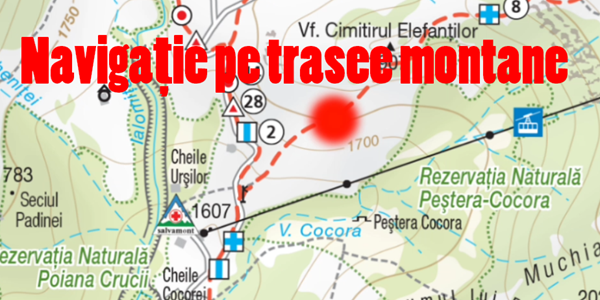
Navigate marked mountain trails
I like going to the mountains, but whoever goes to the mountains and makes routes, knows that sometimes you can miss the marked route.
The attention of mountain tourists on the trails is easily distracted by the superb scenery that changes from one minute to another and more superb.
How can you get lost on the mountain?
Without realizing, with the eyes of royal blossoms and black goats, you can wake up outside the trail, on paths made by shepherds or forest workers, who do not go anywhere.
The problem with Google Maps apps and other similar apps!
If you lost your route and open your phone with Google Maps, you will be amazed at how empty the map is, so yes there are no mountain trails on Google Maps.
Maybe in the future there will be mountain trails on Google Maps, but now it's nothing.
Navigation on the game through the mountains Google maps in Beta!
If you try a route, for example Busteni - Babele, Google maps will offer to guide you, this on an empty map, on which I honestly would not rely even 1%.
Other navigation programs or mountain locations have not been found!
There may be programs for navigation and exact localization through the mountains (in relation to the marked trails), but I have not found them. If you know anything, please put them in the comment box.
But what's the problem with navigation on mountain routes?
The problem is not GPS location, because that can be done quite accurately.
The real problem is finding the exact location in relation to the marked stake.
What are marked trails (for whom they do not know).
To make a mountain trail, for example from Babele to Omu, you have to follow a marked path marked with a sign, in our case the sign has a Yellow Line.
The tourist, in order to reach the destination, must follow the Galbena Line.
These yellow lines are on pillars, drawn on rocks, trees, etc.
If we lose track, and we do not see the signs anymore, we do not know where to go, so it is good to know our location in relation to the marked route.
If we have turned around, we will know how far we have turned and what direction.
Navigation on marked mountain trails - the application.
What better app I found for my hiking trails!
The application is called Our Mountains And is basically a collection of digitized maps with mountain routes in Romania.
Overlay maps are applied with a location layer and BINGO, we can find the exact location in relation to the marked trace.
Suggestion
Use the "Device only" location settings, which means only GPS location, not phone poles, because these poles can ruin your exact location.
CAREFUL:
Install the home app because there are downloadable maps, and you may not have a GSM signal in the area where you are on the mountain.


It's ok for using local maps, but much better is Locus, for example, and many more. Vector and varied maps, navigation, etc
I downloaded, merci, I'm going to study the application.
Maps.ME. Troubled on unmarked routes; Shows exactly where you are. Good! It only requires GPS connection after downloading the areas of interest on the map.
Very Hard Maps ME.
If he had the trail mark it was 5 star.
Thanks for the info, it's louder than what I presented in the tutorial. If there were also the markings….
Yes Maps ME is loud. He knows the routes around Piatra Neamt. Verified by me in the area. From my point of view I RECOMMEND!
I use View Ranger on the mountain, has most of the paths and can use different maps with multiple leyers and can record trak gps with many details (distance, distance, times, etc.) that can be shared and followed by other users.
For hiking trails try Locus and OsmAnd.
You will be surprised what details they have. Bafta on the trails!